Instrument Rating Formula Collection
Complete formula collection for the Instrument Rating - navigation, radio aids, altimetry, pressure corrections, airspeed conversions, gyroscopic drift, and bearing diagrams.
On this page
A comprehensive formula reference for the Instrument Rating, covering navigation calculations, radio aids, altimetry, and essential rules of thumb.
Navigation & Bearing Diagram
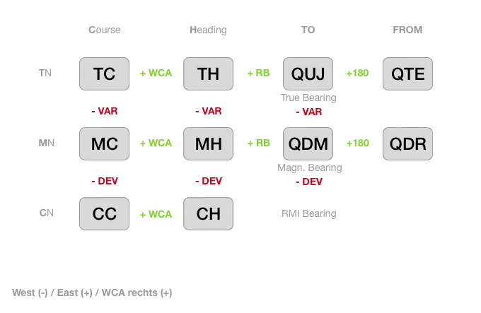
West (-) / East (+) / WCA rechts (+)
Rules of Thumb
Speed
Knots to km/h: (Knots x 2) — 10% = km/h
Altitude
| m -> ft | m * 3.28 | (m * 3) + 10% |
|---|---|---|
| ft -> m | ft / 3.28 | (ft / 3) — 10% |
15,000 ft = 4.75 km
Distance / Speed
| km -> NM | km / 1.852 | (km / 2) + 10% |
|---|---|---|
| NM (kts) -> km (/h) | NM * 1.852 | (NM x 2) — 10% |
Descent Rate (ft/min) for 3-Degree Standard Approach
GS (in kts) x 5
Fuel Volume
| Liters -> US-Gal | Liters / 3.78 | (Liters / 4) + 5% |
|---|---|---|
| US-Gal -> Liters | US-Gal * 3.78 | (US-Gal * 4) - 5% |
- 92 gal = 348 liters (Full refueling Cirrus SR22)
- 46 gal = 174 liters (To the tabs — half refueling Cirrus SR22)
Cloud Height
Cloud Height (ft AGL) = Spread (in Kelvin) x 400
Surface and Altitude Wind
- 2000 ft AGL: + 30 degrees wind veering to the right, wind speed x 2
Stall Speed in Turns
| Bank Angle | 0° | 30° | 45° | 60° | 75° |
|---|---|---|---|---|---|
| Factor | 1 | 1.1 | 1.2 | 1.4 | 2.0 |
True Airspeed (TAS)
Indicated airspeed (IAS) plus 2% of the indication per 1000 ft altitude.
Radio Navigation Formulas
VOR/DME Range
Range (NM) = 1.25 x (√height_station + √FL(ft))
FL(ft) = (Range(ft) / 1.25 - √height)²
Wind Correction Angle (WCA)
WCA = Wind Diff Angle x Wind Speed / TASRMI Bearing
RB = QDM(ADF pointer) - MHIf negative: add 360°
Distance to DME
Distance = Altitude(ft) / 6000(6000 ft = 1 NM above DME)
NDB Bearings
- Towards NDB → relative bearing = 0°
- Away from NDB → relative bearing = 180°
Slant Range
Slant range = (time(ms) - 50) / 12.36
DMEdist² = dist_hor² + height²
Wave Length
Wave length = speed of light (300,000 km/s) / frequency (Hz)Rate of Descent
Rate of Descent = GS x 5Every 10 kt in GS = 50 ft/min
1:60 Rule
At 60 NM → 1° = 1 NM At 100 NM → 1° = 1.5 NM; 5 NM offset at 100 NM = 3°
Max Radar Range
Range = c / (2 x PRF)
PRF = c / (2 x Range)- c = 3 x 10⁸ m/s (for meters or km)
- c = 162,000 NM/s (for NM)
GS on ILS with Glideslope Out
GS out → LOC approach (GS out)
Headwind Component
Headwind = cos(angle°) x Wind SpeedAltimetry & Pressure
ISA Temperature at Altitude
T(ISA) = 15° - (FL / 10) x 2(-2°C per 1000 ft, -0.65°C per 100 m)
Pressure Altitude Corrections
| At Altitude | 1 hPa = |
|---|---|
| MSL | 27 ft |
| 10,000 ft | 36 ft |
| 18,000 ft / 5,500 m | 50 ft / 15 m |
QFE / QNH Relationship
- QFE from QNH: 27 ft = 1 hPa
- QFE < QNH above MSL
- Temp > ISA → QNH > QFF (below sea level: inverted)
Layer Thickness
Layer thickness = Δ height(ft) + (0.004 x Δ height(ft) x Δ temp(°C))Altitude Correction Chain
PA  (Altimeter set to ISA)
 + Δ QNH
QNHA (Altimeter set to QNH)
 + Δ temp
TA   (dangerous Δ - instrument over-reads)
Memory aid: H → L → T → R → H
Standard ISA Pressure Levels
| Pressure | Flight Level | Temperature |
|---|---|---|
| 700 hPa | FL100 | -5°C |
| 500 hPa | FL180 | -21°C |
| 300 hPa | FL300 | -45°C |
Density, Pressure, Temperature
Temperature rises → pressure rises (density: linear, pressure: negative with temp)
Conversions
- 1000 ft = 0.305 km (rule of thumb: /3 - 10%)
- 1000 m = 540 NM
- 1 km = 0.54 NM
Airspeed Conversions
I AS  - Indicated Airspeed (read from airspeed indicator)
  ↓ Instrument & Position error (if absent: CAS = IAS)
C AS  - Calibrated Airspeed (Pt - Ps)
  ↓ Compression (>200 kt)
E AS  - Equivalent Airspeed
  ↓ + Density (fall in temp)
T AS  - True Airspeed (increases with height)
Gyroscopic Precession (Apparent Drift)
| Latitude | Drift Rate |
|---|---|
| 0° (equator) | 0°/h |
| 30°N | 7.5°/h to right (~1/4) |
| 45°N | 10.5–11°/h to right |
| 60°N | 13°/h to right |
| 90°N (pole) | 15°/h max |
Southern hemisphere: drift is to the left (30°S = 7.5°/h to left).
Related articles
LPV vs LNAV/VNAV - Understanding RNAV Approach Minimums
A complete breakdown of the differences between LPV and LNAV/VNAV approaches, including WAAS, SBAS requirements, decision altitudes, and when to use each type.
Updating Garmin Perspective (G1000) Navigation Data via SD Cards
Step-by-step guide to updating navdata, obstacles, terrain, and charts on the Cirrus Perspective system using three SD cards -- including the correct circuit breaker sequence.
The Circling Approach - Finally Explained So It Actually Makes Sense
A step-by-step technique for flying the circling approach with confidence - the 45° break, 30-second rule, half-track-width correction, and constant-angle final turn. With Cirrus SR22T examples.