Formelsammlung Instrument Rating
Vollständige Formelsammlung für das Instrument Rating - Navigation, Funknavigation, Altimetrie, Druckkorrekturen, Geschwindigkeitsumrechnungen, Kreiselpräzession und Peilungsdiagramme.
Auf dieser Seite
Eine umfassende Formelreferenz für das Instrument Rating, die Navigationsberechnungen, Funknavigation, Altimetrie und wichtige Faustregeln abdeckt.
Navigations- und Peilungsdiagramm
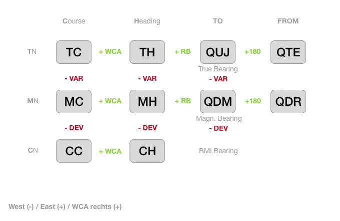
West (-) / East (+) / WCA rechts (+)
Faustregeln
Geschwindigkeit
Knoten in km/h: (Knoten x 2) — 10% = km/h
Höhe
| m -> ft | m * 3,28 | (m * 3) + 10% |
|---|---|---|
| ft -> m | ft / 3,28 | (ft / 3) — 10% |
15.000 ft = 4,75 km
Entfernung / Geschwindigkeit
| km -> NM | km / 1,852 | (km / 2) + 10% |
|---|---|---|
| NM (kts) -> km (/h) | NM * 1,852 | (NM x 2) — 10% |
Sinkrate (ft/min) für 3-Grad-Standardanflug
GS (in kts) x 5
Kraftstoffvolumen
| Liter -> US-Gal | Liter / 3,78 | (Liter / 4) + 5% |
|---|---|---|
| US-Gal -> Liter | US-Gal * 3,78 | (US-Gal * 4) - 5% |
- 92 gal = 348 Liter (Volltankung Cirrus SR22)
- 46 gal = 174 Liter (Bis zu den Tabs - halbe Betankung Cirrus SR22)
Wolkenhöhe
Wolkenhöhe (ft AGL) = Spread (in Kelvin) x 400
Boden- und Höhenwind
- 2000 ft AGL: + 30 Grad Rechtsdrehung des Windes, Windgeschwindigkeit x 2
Überziehgeschwindigkeit in Kurven
| Querneigung | 0° | 30° | 45° | 60° | 75° |
|---|---|---|---|---|---|
| Faktor | 1 | 1,1 | 1,2 | 1,4 | 2,0 |
Wahre Fluggeschwindigkeit (TAS)
Angezeigte Fluggeschwindigkeit (IAS) plus 2% der Anzeige pro 1000 ft Höhe.
Funknavigationsformeln
VOR/DME Reichweite
Reichweite (NM) = 1,25 x (√Höhe_Station + √FL(ft))
FL(ft) = (Reichweite(ft) / 1,25 - √Höhe)²
Windkorrekturwinkel (WCA)
WCA = Winddifferenzwinkel x Windgeschwindigkeit / TASRMI-Peilung
RB = QDM(ADF-Zeiger) - MHWenn negativ: 360° addieren
Entfernung zum DME
Entfernung = Höhe(ft) / 6000(6000 ft = 1 NM über dem DME)
NDB-Peilungen
- Zum NDB → relative Peilung = 0°
- Vom NDB weg → relative Peilung = 180°
Schrägentfernung (Slant Range)
Slant range = (Zeit(ms) - 50) / 12,36
DMEdist² = dist_hor² + Höhe²
Wellenlänge
Wellenlänge = Lichtgeschwindigkeit (300.000 km/s) / Frequenz (Hz)Sinkrate
Sinkrate = GS x 5Alle 10 kt GS = 50 ft/min
1:60-Regel
Bei 60 NM → 1° = 1 NM Bei 100 NM → 1° = 1,5 NM; 5 NM Versatz bei 100 NM = 3°
Maximale Radarreichweite
Reichweite = c / (2 x PRF)
PRF = c / (2 x Reichweite)- c = 3 x 10⁸ m/s (für Meter oder km)
- c = 162.000 NM/s (für NM)
GS bei ILS mit Gleitweg-Ausfall
GS out → LOC-Anflug (GS out)
Gegenwindkomponente
Gegenwind = cos(Winkel°) x WindgeschwindigkeitAltimetrie & Druck
ISA-Temperatur in der Höhe
T(ISA) = 15° - (FL / 10) x 2(-2°C pro 1000 ft, -0,65°C pro 100 m)
Druckhöhenkorrekturen
| In Höhe | 1 hPa = |
|---|---|
| MSL | 27 ft |
| 10.000 ft | 36 ft |
| 18.000 ft / 5.500 m | 50 ft / 15 m |
QFE / QNH Zusammenhang
- QFE aus QNH: 27 ft = 1 hPa
- QFE < QNH über MSL
- Temp > ISA → QNH > QFF (unter Meeresniveau: umgekehrt)
Schichtdicke
Schichtdicke = Δ Höhe(ft) + (0,004 x Δ Höhe(ft) x Δ Temp(°C))Höhenkorrekturkette
PA  (Höhenmesser auf ISA eingestellt)
 + Δ QNH
QNHA (Höhenmesser auf QNH eingestellt)
 + Δ Temp
TA   (gefährliches Δ - Instrument zeigt zu viel an)
Merkhilfe: H → L → T → R → H
Standard-ISA-Druckniveaus
| Druck | Flugfläche | Temperatur |
|---|---|---|
| 700 hPa | FL100 | -5°C |
| 500 hPa | FL180 | -21°C |
| 300 hPa | FL300 | -45°C |
Dichte, Druck, Temperatur
Temperatur steigt → Druck steigt (Dichte: linear, Druck: negativ mit Temp)
Umrechnungen
- 1000 ft = 0,305 km (Faustregel: /3 - 10%)
- 1000 m = 540 NM
- 1 km = 0,54 NM
Geschwindigkeitsumrechnungen
I AS  - Indicated Airspeed (abgelesen am Fahrtmesser)
  ↓ Instrumenten- und Positionsfehler (wenn nicht vorhanden: CAS = IAS)
C AS  - Calibrated Airspeed (Pt - Ps)
  ↓ Kompressibilität (>200 kt)
E AS  - Equivalent Airspeed
  ↓ + Dichte (Temperaturabfall)
T AS  - True Airspeed (steigt mit der Höhe)
Kreiselpräzession (scheinbare Drift)
| Breitengrad | Driftrate |
|---|---|
| 0° (Äquator) | 0°/h |
| 30°N | 7,5°/h nach rechts (~1/4) |
| 45°N | 10,5–11°/h nach rechts |
| 60°N | 13°/h nach rechts |
| 90°N (Pol) | 15°/h max |
Südhalbkugel: Drift nach links (30°S = 7,5°/h nach links).
Verwandte Artikel
LPV vs LNAV/VNAV - RNAV-Anflugminima verstehen
Ein vollständiger Vergleich der Unterschiede zwischen LPV- und LNAV/VNAV-Anflügen, einschließlich WAAS-, SBAS-Anforderungen, Entscheidungshöhen und wann welcher Typ verwendet wird.
Garmin Perspective (G1000) Navigationsdaten per SD Card aktualisieren
Schritt-für-Schritt-Anleitung zum Aktualisieren von NavData, Hindernissen, Gelände und Charts im Cirrus Perspective System mit drei SD Cards -- inklusive der richtigen Circuit Breaker-Reihenfolge.
Der Circling-Anflug - Endlich so erklärt, dass er wirklich Sinn ergibt
Eine Schritt-für-Schritt-Technik für den Circling-Anflug mit Zuversicht - der 45°-Break, die 30-Sekunden-Regel, die halbe Spurbreiten-Korrektur und die Endkurve mit konstantem Winkel. Mit Cirrus SR22T Beispielen.